- Conclusion: Sections of the Shikoku Pilgrimage with Few Convenience Stores
- 372 Convenience Stores Available to Walking Pilgrims: Survey Method and Results
- Number of Convenience Stores Along the Shikoku Pilgrimage by Prefecture
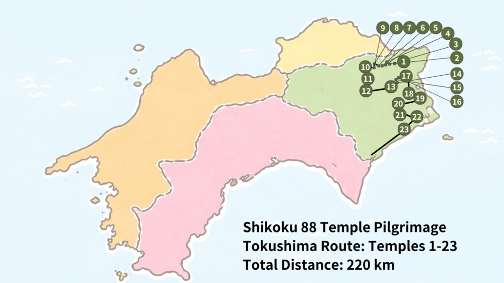
- Convenience Store Map for Walking Pilgrims in Tokushima Prefecture
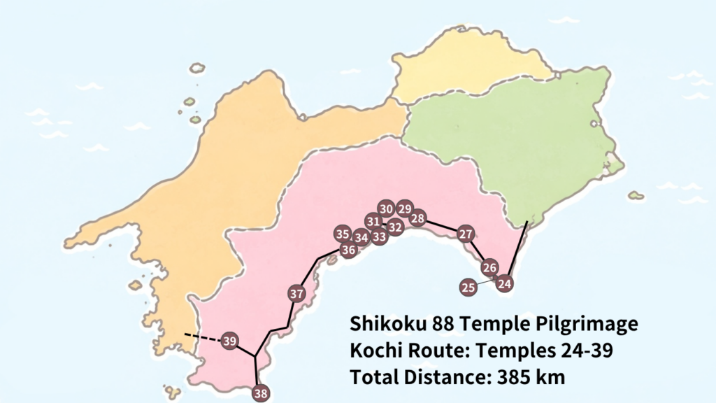
- Convenience Store Map for Walking Pilgrims in Kochi Prefecture
- Convenience Store Map for Walking Pilgrims in Ehime Prefecture
- Convenience Store Map for Walking Pilgrims in Kagawa Prefecture
- Top 5 Convenience-Store-Free Stretches on the Shikoku Pilgrimage
- The Most Challenging Resupply Sections for Walking Pilgrims
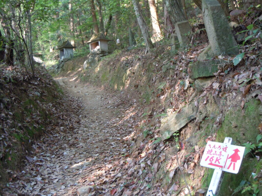
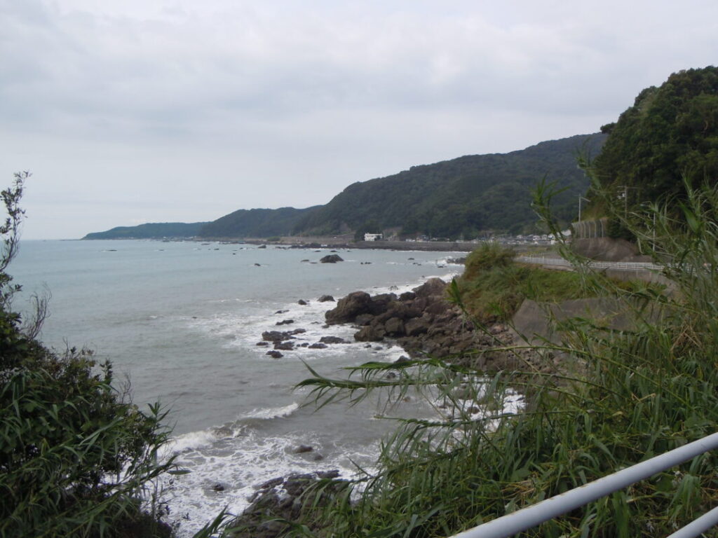
- #1: Temples No. 23–24 (Yakuō-ji to Hotsumisaki-ji)
- #2: Temples No. 11–16 (Shōsan-ji / Henro Korogashi)
- #3: Temples No. 43–44 (Meiseki-ji to Daihō-ji)
- #4: Temples No. 37–38 (Iwamoto-ji to Kongōfuku-ji)
- #5: Temples No. 65–66 (Sankaku-ji to Unpen-ji)
- FAQ: Convenience Stores on the Walking Shikoku Pilgrimage
- Conclusion
- Related Articles
- Walking Shikoku Pilgrimage Resupply Points List
Conclusion: Sections of the Shikoku Pilgrimage with Few Convenience Stores
Based on a survey of 372 convenience stores accessible along the Shikoku Pilgrimage route, the longest stretch without a convenience store is approximately 47 km between Temple No. 23, Yakuō-ji, and Temple No. 24, Hotsumisaki-ji.
The following five sections require particular attention when planning food and water supplies:
- Temple No. 23 Yakuō-ji → Temple No. 24 Hotsumisaki-ji (approx. 47 km)
- Temple No. 11 Fujii-dera → Temple No. 16 Kannon-ji (approx. 42 km)
- Temple No. 43 Meiseki-ji → Temple No. 44 Daihō-ji (approx. 33 km)
- Temple No. 37 Iwamoto-ji → Temple No. 38 Kongōfuku-ji (approx. 32 km)
- Temple No. 65 Sankaku-ji → Temple No. 66 Unpen-ji (approx. 30 km)
Even in Kagawa Prefecture, where the distances between temples are generally shorter, there are convenience-store-free stretches of around 20 km, making advance supply planning essential.
In this article, we analyze 372 convenience stores located along the walking pilgrimage route, providing an overview of their distribution by prefecture and highlighting sections where obtaining supplies can be difficult, complete with a heat map for easy reference.
372 Convenience Stores Available to Walking Pilgrims: Survey Method and Results
In this article, we surveyed the number of convenience stores available along the walking route of the Shikoku 88 Temple Pilgrimage.
Our research found a total of 372 convenience stores that can be conveniently accessed by walking pilgrims.
The survey was conducted using Google Maps, with each location listed under the search term “convenience store” individually reviewed. Only stores that could be visited without a significant detour from the walking pilgrimage route were included.
The following types of facilities were excluded from the survey:
- Supermarkets
- Drugstores
- Small shops and kiosks
- Convenience stores located far from the walking pilgrimage route
The survey is based on the latest data available for fiscal year 2026. Please note that the actual number of stores may change over time due to new openings, closures, or relocations.
| Convenience Store Chain | Number of Stores | Share |
|---|---|---|
| Lawson | 153 | 41.1% |
| FamilyMart | 121 | 32.5% |
| 7-Eleven | 84 | 22.6% |
| Others | 14 | 3.8% |
| Total | 372 | 100% |
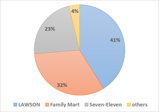
Approximately 40% of all convenience stores available to walking pilgrims are Lawson locations, making Lawson the most common chain along the Shikoku Pilgrimage route. It is followed by FamilyMart and 7-Eleven.
Across the Shikoku region, Lawson and FamilyMart have the strongest presence, and they are likely to be the convenience store chains that walking pilgrims encounter and use most frequently during their journey.
Number of Convenience Stores Along the Shikoku Pilgrimage by Prefecture
We compiled the number of convenience stores available to walking pilgrims by prefecture.
| Prefecture | Temple Numbers | Approx. Distance | Convenience Stores |
|---|---|---|---|
| Tokushima | 1–23 | Approx. 220 km | 60 stores |
| Kochi | 24–39 | Approx. 385 km | 82 stores |
| Ehime | 40–65 | Approx. 360 km | 155 stores |
| Kagawa | 66–88 | Approx. 152 km | 75 stores |
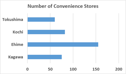
The availability and density of convenience stores vary considerably across the four prefectures of the Shikoku Pilgrimage route. To help pilgrims plan food and water resupply stops, we analyzed the number of convenience stores in each prefecture.
Looking not only at the total number of stores but also at their distribution in relation to the walking distance can help identify areas where resupply is relatively easy and areas where extra preparation is required.
Convenience Store Map for Walking Pilgrims in Tokushima Prefecture
Resupply Conditions Between Temple No. 1 and Temple No. 23
The availability of convenience stores varies significantly throughout the Tokushima section of the Shikoku Pilgrimage. To help pilgrims plan their food and water resupply stops, we have mapped the distribution of convenience stores between Temple No. 1 and Temple No. 23 and highlighted key resupply points along the route.
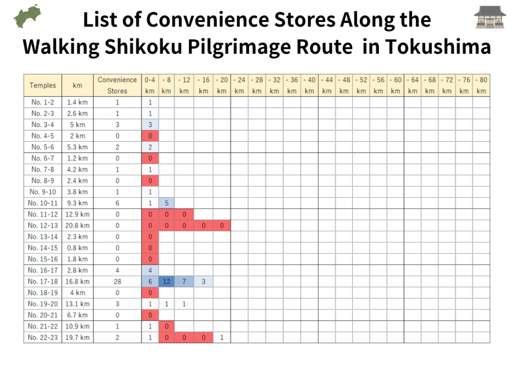
This heat map visualizes the distribution of convenience stores along the walking pilgrimage route on a section-by-section basis between temples. Each grid cell represents approximately 4 km, which corresponds to about one hour of walking at an average pace of 4 km/h.
By examining the color intensity, pilgrims can quickly identify:
- Areas with a high concentration of convenience stores
- Areas with limited resupply options
- Long stretches with no convenience stores at all
This makes it easier to plan daily walking distances and ensure adequate food and water supplies before entering less-developed sections of the route.
In addition, the location details of every convenience store included in this survey are listed at the end of this article. Clicking on a convenience store name will take you directly to its corresponding location information.
Temple No. 11 Fujii-dera to Temple No. 12 Shōsan-ji
Henro Korogashi and a Convenience-Store-Free Stretch of Approximately 42 km
The mountain trail leading to Temple No. 12 Shōsan-ji, commonly known as “Henro Korogashi” (Pilgrim’s Rolling Slope), is one of the most challenging sections of the Shikoku Pilgrimage. With its steep ascents and descents, it typically takes walking pilgrims 6 to 9 hours to complete.
The area around Shōsan-ji is widely known for its limited resupply options. However, our survey shows that the convenience-store shortage extends well beyond the mountain trail itself.
Several convenience stores are available in the Kamojima area at the foot of the mountain. Beyond that point, however, resupply opportunities become extremely scarce. The next convenience store accessible from the pilgrimage route is FamilyMart Tokushima Kokufu-cho, located near Temple No. 16 Kannon-ji.
As a result, pilgrims leaving the Kamojima area face a convenience-store-free stretch of approximately 42 km. This is not only one of the longest such sections in Tokushima Prefecture, but also one of the longest on the entire Shikoku Pilgrimage route.
Further details can be found in the ranking article below:
Temple No. 20 Kakurin-ji to Temple No. 21 Tairyu-ji
A Challenging Section with a 16 km Convenience-Store Gap and Nearly 1,000 m of Total Elevation Change
The route between Temple No. 20 Kakurin-ji and Temple No. 21 Tairyu-ji is another demanding section of the walking Shikoku Pilgrimage and is often classified as a “Henro Korogashi” (Pilgrim’s Rolling Slope) route.
In terms of resupply opportunities, there are no convenience stores for approximately 16 km, beginning at FamilyMart Tokushima Katsura Town Store at the foot of Kakurin-ji and continuing until the area below Tairyu-ji.
While the distance itself may not seem particularly long, this section requires pilgrims to cross two mountain temples—Kakurin-ji and Tairyu-ji. The cumulative elevation gain and loss is approximately 1,000 meters, making it far more strenuous than the distance alone would suggest.
As a result, most pilgrims find this section significantly more physically demanding than the numbers indicate.
After descending from Tairyu-ji, a Lawson store in Naka Town can be found about 3 km west of the temple area. However, this store is located in the opposite direction from Temple No. 22 Byōdō-ji, meaning it requires a detour away from the official pilgrimage route.
By contrast, Michi-no-Eki Wajiki (Wajiki Roadside Station) is located directly along the pilgrimage route toward Temple No. 22 and offers several useful services:
- Restaurants and light meals
- Rest areas
- Wi-Fi access
Although it does not provide the same selection as a convenience store, it serves as an important rest and resupply point before reaching Byōdō-ji.
When walking this section, it is advisable to purchase sufficient drinking water and trail food in Katsura Town before beginning the climb. Pilgrims can then use Michi-no-Eki Wajiki as a supplementary resupply and rest stop along the way.
Accommodation information for this section is available below.
Best Places to Stay Around Temples 20–22 on the Shikoku Pilgrimage
Temple No. 22 Byōdō-ji to Temple No. 23 Yakuō-ji
An Approximately 18 km Convenience-Store-Free Stretch
The route from Temple No. 22 Byōdō-ji to Temple No. 23 Yakuō-ji is relatively easy to walk compared with some of the mountain sections of the Shikoku Pilgrimage. However, resupply opportunities remain limited.
There are no convenience stores for approximately 18 km, from Lawson Anan Aratano Store to Lawson Hiwasa Teramae Store.
Although there are no convenience stores along this stretch, the communities of Yuki and Kiki, located near the midpoint of the route, offer several restaurants and local shops where pilgrims can purchase food and drinks.
Pilgrims planning to walk long distances, especially during the summer months, are advised to stock up on sufficient water and supplies at convenience stores in the Anan area before setting out.
Accommodation information for this section is available below.
Best Accommodation for Walking Pilgrims Near Temple 23 Yakuo-ji
For a guide to this section using public transportation, see the article below.
How to Travel from Temple 22 Byodoji to Temple 23 Yakuoji by Train
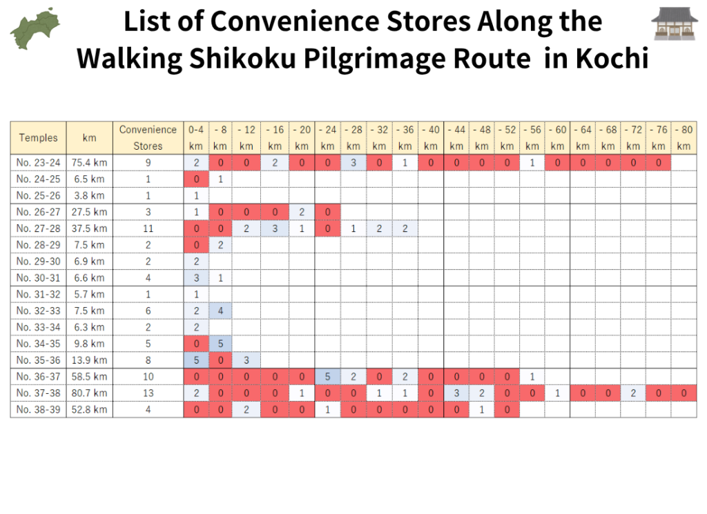
Convenience Store Map for Walking Pilgrims in Kochi Prefecture
Resupply Points Between Temple No. 24 and Temple No. 39
The walking pilgrimage route through Kochi Prefecture spans approximately 385 km, making it the longest section of the Shikoku Pilgrimage. As a result, there are numerous stretches with few or no convenience stores, requiring careful resupply planning.
To avoid running short of food, drinks, or other essentials, pilgrims should familiarize themselves with the distribution of convenience stores around each temple before starting their journey. Understanding where resupply opportunities are available can make a significant difference, especially in the more remote coastal and rural sections of Kochi.
Temple No. 23 Yakuō-ji to Temple No. 24 Hotsumisaki-ji
Careful Resupply Planning Is Essential on the Cape Muroto Route
The Cape Muroto route between Temple No. 23 Yakuō-ji and Temple No. 24 Hotsumisaki-ji is a long-distance section of approximately 75 km. It is the second-longest distance between temples on the Shikoku Pilgrimage, and most walking pilgrims take two to three days to complete it.
The latter half of the route, particularly as pilgrims approach Cape Muroto, has relatively few convenience stores. As a result, careful planning for food and water resupply is essential. Opportunities to purchase supplies are limited, and insufficient preparation can make this section significantly more challenging.
For a detailed analysis of convenience store availability along this route, see the Convenience Store Gap Ranking article below.
Temple No. 26 Kongōchō-ji to Temple No. 27 Kōnomine-ji
Missing Convenience Okazaki Means Nearly 20 km Without a Convenience Store
On the route from Temple No. 26 Kongōchō-ji to Temple No. 27 Kōnomine-ji, Convenience Okazaki serves as a key resupply point for walking pilgrims.
If you choose not to stop at Convenience Okazaki, the next convenience store is Lawson Nahari Town Store, located approximately 15 km away.
In addition, the nearest convenience store before reaching Kongōchō-ji is Lawson Muroto City Hall Store, situated about 4 km before the temple. This creates the following sequence of resupply points:
Lawson Muroto City Hall Store → Convenience Okazaki → Lawson Nahari Town Store
As a result, pilgrims who bypass Convenience Okazaki effectively face a stretch of nearly 20 km without a convenience store.
This section also includes the challenging ascent and descent associated with Kōnomine-ji, making it more physically demanding than the distance alone suggests. Pilgrims who are concerned about their water supply or trail food should consider resupplying at Convenience Okazaki before continuing their journey.
Accommodation information for this section is available below.
Shikoku Pilgrimage Accommodation Guide: Temples 25–27 (Cape Muroto–Nahari)
For a guide to this section using public transportation, see the article below.
Shikoku 88 Temple Route Guide: Temples 24–27 by Bus
Temple No. 36 Shōryū-ji to Temple No. 37 Iwamoto-ji
Watch Out for Two Long Convenience-Store-Free Sections
The route from Temple No. 36 Shōryū-ji to Temple No. 37 Iwamoto-ji is generally considered a relatively easy section of the Shikoku Pilgrimage. However, pilgrims should be aware of two lengthy stretches with limited resupply opportunities.
The first section of concern lies between FamilyMart Tosa Usa Store and 7-Eleven Susaki Kirima-Minami Store.
There are no convenience stores for approximately 25 km along this stretch. Since FamilyMart Tosa Usa Store is located about 4 km before Shōryū-ji, pilgrims are advised to stock up on water and trail food before visiting the temple and continuing onward.
The second resupply gap occurs later in the route.
Between FamilyMart Nakatosa Kure Store and Lawson Shimanto Town Chuo Inter Store, there are no convenience stores for approximately 17 km.
While the distance itself may not seem particularly long, pilgrims must cross Nanako Pass, which reaches an elevation of approximately 300 meters. The prolonged uphill climb can make this section considerably more demanding than the distance alone would suggest, increasing the importance of carrying adequate food and water supplies.
Accommodation information for this section is available below.
Best Accommodation Between Temple 36 and 37
Temple No. 37 Iwamoto-ji to Temple No. 38 Kongōfuku-ji
The Longest Temple-to-Temple Section, Yet Surprisingly Well Supplied with Convenience Stores
The route from Temple No. 37 Iwamoto-ji to Temple No. 38 Kongōfuku-ji is one of the longest temple-to-temple sections on the Shikoku Pilgrimage. Despite its considerable distance, a review of convenience store locations shows that resupply opportunities are available at reasonable intervals, making the route manageable with proper planning.
The Most Challenging Part: Kuroshio Town to Shimanto City
The most demanding resupply section in the first half of the route lies between Kuroshio Town and Shimanto City.
Along this approximately 32 km stretch, the only convenience store available is Lawson Kuroshio Saga Store. Missing this resupply point can leave pilgrims without access to a convenience store for an extended period, making careful planning essential.
Further details can be found in the article below:
The Second Challenging Section: Shimanto River to Tosashimizu
After crossing the Shimanto River, resupply opportunities remain limited until reaching Tosashimizu City, just before Cape Ashizuri.
Along this stretch, the only convenience store is Lawson Tosashimizu Shimonokae Store. The distances to the nearest convenience stores on either side are approximately 15 km and 12 km, respectively. This means that resupply options are limited across a total distance of about 27 km, making it advisable to carry sufficient water and trail food.
Lawson Shimanto Takeshima Store (approx. 15 km) → Lawson Tosashimizu Shimonokae Store (approx. 12 km) → Lawson Tosashimizu Asahimachi Store
Accommodation information for this section is available below.
Shikoku Pilgrimage Accommodation Guide: Shimanto to Cape Ashizuri
Cape Ashizuri (Temple No. 38 Kongōfuku-ji)
No Convenience Stores Along the 28 km Round Trip from Tosashimizu
Once pilgrims leave the urban area of Tosashimizu City and head toward Cape Ashizuri, where Temple No. 38 Kongōfuku-ji is located, there are no convenience stores along the route.
The distance from central Tosashimizu to Cape Ashizuri is approximately 14 km one way, resulting in a 28 km round trip. Because there are no convenience stores on this section, pilgrims should purchase sufficient water and snacks before leaving Tosashimizu.
That said, the Cape Ashizuri area does offer several souvenir shops and restaurants where visitors can buy light meals and drinks. These facilities can serve as useful lunch and rest stops during the visit to Kongōfuku-ji and the cape.
Accommodation information for this section is available below.
Where to Stay Near Cape Ashizuri | Temple 38
Around Temple No. 39 Enkō-ji
An Approximately 28 km Convenience-Store-Free Stretch
On the route from Temple No. 38 Kongōfuku-ji toward Temple No. 39 Enkō-ji, there are no convenience stores for approximately 28 km, between Lawson Tosashimizu Shimonokae Store and Lawson Sukumo Hiratacho Store.
This section passes through a largely mountainous and rural area where opportunities to purchase food and drinks are limited. In addition to the long distance, the lack of resupply points makes careful preparation especially important.
During the summer months, pilgrims should pay particular attention to hydration and ensure they carry enough water for the journey.
Before heading toward Enkō-ji, it is strongly recommended to stock up on drinking water, snacks, and other essentials at Lawson Tosashimizu Shimonokae Store, as it is the last reliable convenience-store resupply point before this long stretch.
Accommodation information for this section is available below.
Shikoku Henro Accommodation Guide | Mihara Village Route to Temple 39
For a guide to this section using public transportation, see the article below.
Shikoku Pilgrimage: Temple 38 to Temple 39 by Train and Bus
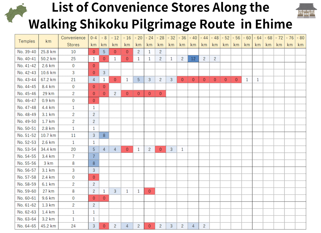
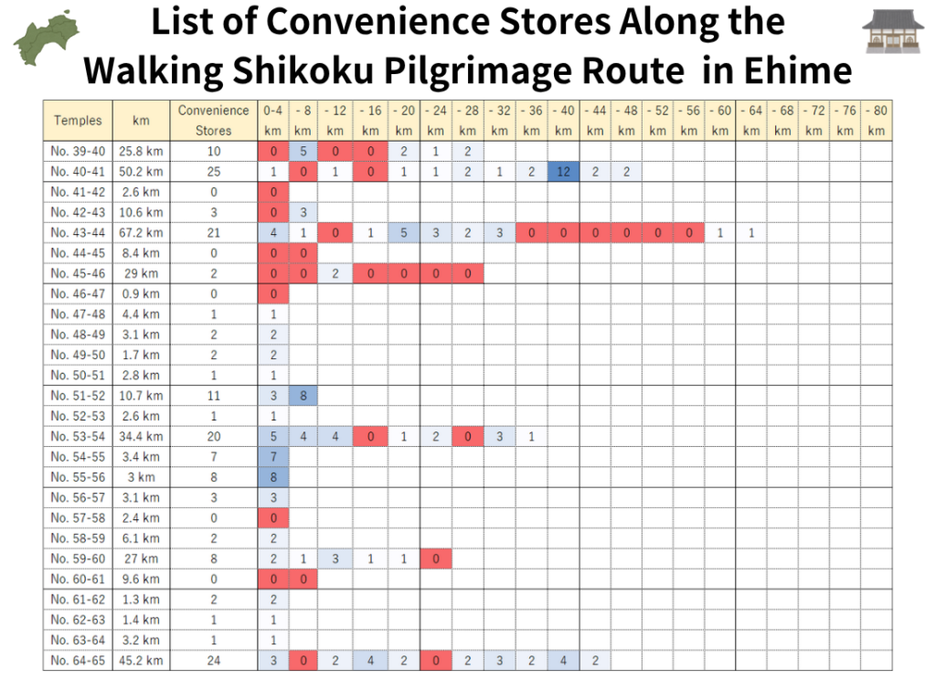
Convenience Store Map for Walking Pilgrims in Ehime Prefecture
Understanding Resupply Conditions Between Temple No. 40 and Temple No. 65
The Ehime Prefecture section of the Shikoku Pilgrimage has the highest number of convenience stores among the four prefectures of Shikoku. As a result, walking pilgrims generally have fewer difficulties finding food, drinks, and other daily necessities compared with other parts of the route.
However, convenience-store-free stretches still exist between certain temples, and resupply opportunities are not evenly distributed throughout the prefecture. Checking convenience store locations in advance can help pilgrims avoid unexpected shortages of water and food.
Use the map and heat map to identify key resupply points and plan your daily walking schedule accordingly. Understanding where convenience stores are concentrated—and where they are not—can make your pilgrimage safer and more comfortable.
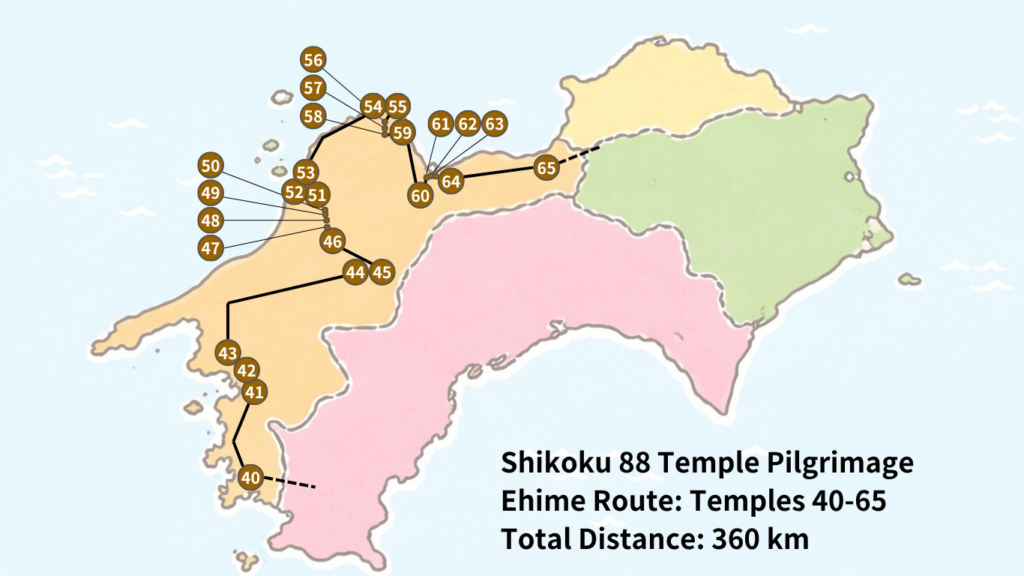
Temple No. 43 Meiseki-ji to Temple No. 44 Daihō-ji
An Approximately 33 km Convenience-Store-Free Stretch
On the route from Temple No. 43 Meiseki-ji to Temple No. 44 Daihō-ji, there are no convenience stores for approximately 33 km, between FamilyMart Uchiko Store and Lawson Kumakogen Kuma Store.
This section is challenging not only because of its distance but also because it passes through a mountainous area. Pilgrims taking the route via Hiwata Pass will reach elevations of approximately 800 meters, making the journey considerably more demanding than a flat 33 km walk.
Due to the combination of distance and elevation, careful preparation is essential. Pilgrims should ensure they carry sufficient drinking water, food, and other supplies before leaving Uchiko Town.
This section also ranks among the longest convenience-store-free stretches featured in our Convenience Store Gap Ranking.
For a more detailed analysis, see the article below:
Temple No. 45 Iwaya-ji to Temple No. 48 Sairin-ji
An Approximately 25 km Convenience-Store-Free Stretch
On the route from Temple No. 45 Iwaya-ji toward Temple No. 48 Sairin-ji, there are no convenience stores for approximately 25 km, between FamilyMart Kuma Irino Store and FamilyMart Matsuyama Omura-cho Store.
This section follows the route from Kumakogen down toward Matsuyama City, meaning that the overall elevation profile is largely downhill. As a result, it is generally less physically demanding than mountainous pilgrimage sections such as Shōsan-ji or Unpen-ji.
However, the distance remains significant. Covering approximately 25 km, this stretch often requires more than six hours of walking, even under favorable conditions.
Pilgrims are therefore advised to stock up on drinking water, snacks, and other essential supplies before leaving the Kumakogen area, as resupply opportunities are unavailable until reaching the outskirts of Matsuyama.
Accommodation information for this section is available below.
Where to Stay Near Temples 46–52: Matsuyama & Dogo Onsen Accommodation Guide
Temple No. 60 Yokomine-ji
A Challenging Mountain Temple at 750 m Elevation and a 20 km Convenience-Store-Free Stretch
Temple No. 60 Yokomine-ji is one of the most challenging sections of the walking Shikoku Pilgrimage and is often referred to as “Iyo no Henro Korogashi” (Iyo’s Pilgrim’s Rolling Slope).
Located at an elevation of approximately 750 meters, the temple requires a long ascent and descent, making it a notoriously demanding section for many pilgrims.
Resupply conditions are also less than ideal.
There are no convenience stores for approximately 20 km between Ministop Tanbara Imai Store and 7-Eleven Komatsu Shinyashiki Store, which are the nearest convenience stores before and after Yokomine-ji.
While a 20 km stretch may not seem exceptionally long compared with some other sections of the pilgrimage, the physical demands of climbing to and descending from Yokomine-ji significantly increase the importance of proper preparation.
Pilgrims should carry sufficient drinking water before beginning the ascent, particularly during the summer months when dehydration can become a serious concern. Bringing energy bars, snacks, or other trail food is also recommended to help maintain energy levels during this strenuous mountain section.
Accommodation information for this section is available below.
Shikoku Pilgrimage Accommodation Guide: Temples 56–64 and Yokomine-ji
Convenience Store Map for Walking Pilgrims in Kagawa Prefecture
Understanding Resupply Conditions Between Temple No. 66 and Temple No. 88
Kagawa Prefecture marks the final stage of the Shikoku Pilgrimage and has the shortest overall pilgrimage distance among the four prefectures. It is also one of the easiest regions for walking pilgrims to find convenience stores, making food and water resupply generally more accessible than in other parts of Shikoku.
However, convenience-store-free stretches still exist and should not be overlooked. One notable example is the area near the prefectural border between Temple No. 65 Sankaku-ji and Temple No. 66 Unpen-ji, where resupply opportunities are limited despite the overall convenience of the region.
By reviewing the map and heat map in advance, pilgrims can identify key resupply points and avoid unexpected shortages of water, food, and other essential supplies while completing the final stages of their journey.
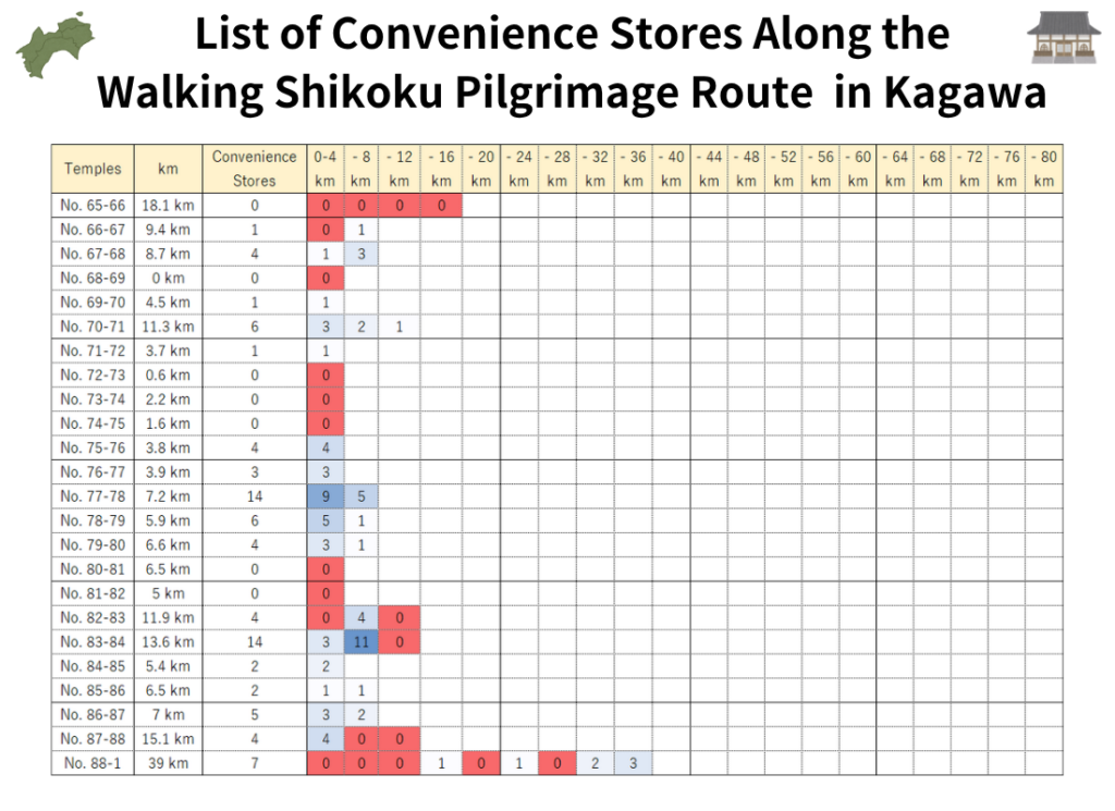
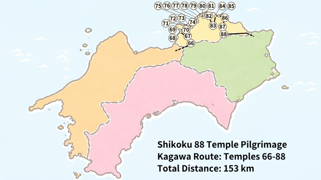
Temple No. 65 Sankaku-ji to Temple No. 66 Unpen-ji
An Approximately 30 km Convenience-Store-Free Stretch
On the route from Temple No. 65 Sankaku-ji to Temple No. 66 Unpen-ji, convenience stores disappear once pilgrims leave the urban area at the foot of Sankaku-ji in Shikokuchuo City. There are no convenience stores until after crossing Unpen-ji and descending to the foothills on the Kagawa Prefecture side.
The distance between the nearest convenience stores before and after this section is approximately 30 km, making it one of the most important stretches on the pilgrimage for careful resupply planning.
Adding to the challenge, Temple No. 66 Unpen-ji is the highest temple on the Shikoku Pilgrimage, situated at an elevation of approximately 900 meters above sea level. The route involves a long ascent followed by a lengthy descent, and many pilgrims find it more physically demanding than a flat 30 km walk.
For this reason, carrying sufficient water, food, and other essentials before beginning the climb is highly recommended.
Further details about convenience store availability and resupply strategies for this section can be found in our Convenience Store Gap Ranking article:
Temple No. 80 Kokubun-ji to Temple No. 83 Ichinomiya-ji
Even Kagawa Has a Convenience-Store-Free Stretch of About 20 km
Kagawa Prefecture is generally considered one of the easiest sections of the Shikoku Pilgrimage for walking pilgrims. Distances between temples are relatively short, and convenience stores are more readily available than in many other parts of the route.
However, somewhat surprisingly, there is a convenience-store-free stretch of approximately 20 km in this area.
After passing FamilyMart Sakaide Fuchu Store, located near Temple No. 80 Kokubun-ji, the next convenience store is Ministop Danshi Store, which is situated on the way to Temple No. 83 Ichinomiya-ji. Between these two stores, there are no convenience stores available for roughly 20 km.
In addition, Temple No. 81 Shiromine-ji and Temple No. 82 Negoro-ji are located on the Goshikidai Plateau at an elevation of approximately 500 meters. Although the distance itself is not particularly long, the repeated climbs and descents can be physically demanding and may require more energy than expected.
For this reason, pilgrims are advised to carry sufficient drinking water and snacks before entering this section.
While Kagawa is generally one of the most convenient prefectures for resupply, this route stands out as an exception and deserves careful preparation.
Temple No. 88 Ōkubo-ji to Temple No. 1 Ryōzen-ji
A 25 km Resupply Gap to Keep in Mind During the Return Pilgrimage
Pilgrims who choose to complete an “Orei Mairi” (return pilgrimage) by visiting Temple No. 1 Ryōzen-ji after reaching Temple No. 88 Ōkubo-ji should pay close attention to resupply opportunities along this route.
After leaving Lawson Sanuki Nagao Myo Store, located at the foot of Ōkubo-ji, pilgrims following Prefectural Route 2 will not encounter another convenience store until FamilyMart Awa Ichiba-machi Kita Store, approximately 25 km away.
This section is made even more challenging by the need to cross Nyotai Mountain, which reaches an elevation of approximately 700 meters. The combination of a long distance and significant elevation change can lead to substantial physical fatigue.
For this reason, pilgrims should ensure they have sufficient drinking water, snacks, and other supplies before setting out.
Because it comes immediately after completing the Shikoku Pilgrimage, this route can be easy to underestimate. However, the Orei Mairi section is actually one of the more demanding stretches for resupply and should be approached with the same level of preparation as other remote sections of the pilgrimage.
Top 5 Convenience-Store-Free Stretches on the Shikoku Pilgrimage
The Most Challenging Resupply Sections for Walking Pilgrims
The Shikoku Pilgrimage includes several remote sections where obtaining food, drinks, and other supplies can be difficult due to the lack of convenience stores.
To help walking pilgrims prepare, we have ranked the most challenging convenience-store-free stretches based on the distance to the next available convenience store. These are the sections where careful planning for water, meals, and emergency supplies is especially important.
#1: Temples No. 23–24 (Yakuō-ji to Hotsumisaki-ji)
A Convenience-Store-Free Stretch of Approximately 47 km
The most challenging section for resupply on the walking Shikoku Pilgrimage is the Cape Muroto route between Temple No. 23 Yakuō-ji and Temple No. 24 Hotsumisaki-ji.
To begin with, the distance between these two temples is approximately 75 km, making it one of the longest temple-to-temple sections on the entire pilgrimage. Resupply conditions become particularly difficult in the latter half of the route, where the only convenience store directly accessible from the walking pilgrimage route is Monmart Muroto.
The distances to the nearest convenience stores before and after Monmart Muroto illustrate just how remote this section is:
- 7-Eleven Kaiyo Shishikui Store (approximately 23 km away)
- Lawson Muroto City Hall Store (approximately 24 km away)
In other words, across a stretch of roughly 47 km, Monmart Muroto is the only convenience store available. This is why the section ranks No. 1 in our Convenience-Store-Free Stretch Ranking.
Most walking pilgrims take two to three days to complete the 75 km journey between Yakuō-ji and Hotsumisaki-ji. Without careful planning, obtaining sufficient food and drinking water can become a significant challenge.
The most critical area is the long coastal section between Kaiyo Town and Cape Muroto, where resupply opportunities are extremely limited. Pilgrims should make sure to carry enough water and food before entering this stretch.
For many walkers, Monmart Muroto is more than just a convenience store—it is the single most important resupply point on the entire Cape Muroto route.
During the summer months in particular, pilgrims are strongly advised to carry extra water and purchase enough supplies at Monmart Muroto to cover not only the remainder of the day but also the following day’s walk.
- 🏪
Section Distance: 23 km
- 🏪
Section Distance: 18 km
- ⛩Temple No. 24 Hotsumisaki-ji
Section Distance: 6 km
- 🏪
Accommodation information for this section is available below.
Where to Stay Between Temple 23 and 24 | Cape Muroto Accommodation Guide for Walking Pilgrims
For a guide to this section using public transportation, see the article below.
Shikoku Pilgrimage Route Guide: Temple 23–24 Transportation & Timetable
#2: Temples No. 11–16 (Shōsan-ji / Henro Korogashi)
Approximately 42 km to the Next Convenience Store
Ranked second is the famous Shōsan-ji route, widely known as “Henro Korogashi” (Pilgrim’s Rolling Slope).
While Shōsan-ji is best known for its steep and demanding mountain trails, the resupply situation is equally challenging. After leaving the Kamojima area near Temple No. 11 Fujii-dera, pilgrims will not encounter another convenience store until the vicinity of Temple No. 16 Kannon-ji.
Based on the locations of the nearest convenience stores before and after this section, there is a convenience-store-free stretch of approximately 42 km.
What makes this section particularly difficult is that the challenge is not limited to distance alone.
The climb from Fujii-dera to Shōsan-ji via the Henro Korogashi trail is one of the most demanding mountain routes on the entire Shikoku Pilgrimage. Pilgrims must endure long hours of steep ascents and descents, resulting in far greater physical exertion than a flat 42 km walk.
There are several pilgrim lodgings and guesthouses around Shōsan-ji, so the lack of convenience stores is generally less problematic for those planning to stay overnight. However, pilgrims intending to camp or sleep outdoors should take extra care when planning their supplies.
In particular, food preparation is essential. Before leaving the Kamojima area, pilgrims are advised to purchase enough food to last through the following day.
A practical guideline is to carry enough for approximately four meals:
- Dinner
- Breakfast the following morning
- Lunch
- Trail snacks and energy food
The Shōsan-ji route is famous for its rugged mountain terrain, but in reality it combines two separate challenges: demanding mountain hiking and extremely limited resupply opportunities. This combination makes it one of the most difficult sections of the walking Shikoku Pilgrimage.
- 🏪
Section Distance: 3 km
- ⛩No. 11 Fujii-dera
Section Distance: 13 km
- ⛩No. 12 Shōsan-ji
Section Distance: 21 km
- ⛩No. 13 Dainichi-ji
Section Distance: 2 km
- ⛩No. 14 Jōraku-ji
Section Distance: 1 km
- ⛩No. 15 Kokubun-ji
Section Distance: 2 km
- ⛩No. 16 Kanon-ji
Section Distance: 0.5 km
- 🏪
Accommodation information for this section is available below.
Best Accommodation for Shikoku Pilgrimage Temples 12–19
#3: Temples No. 43–44 (Meiseki-ji to Daihō-ji)
A 33 km Convenience-Store-Free Stretch Through Mountain Terrain Reaching 800 m Elevation
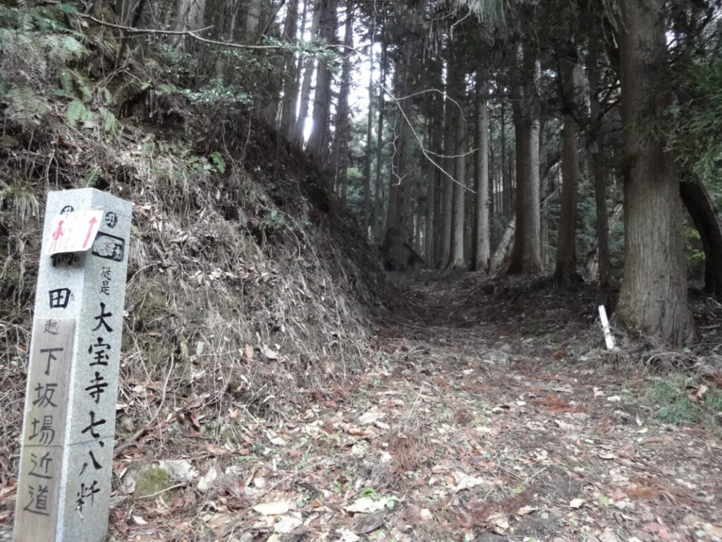
Ranked third is the route between Temple No. 43 Meiseki-ji and Temple No. 44 Daihō-ji.
The defining characteristics of this section are its long distance and significant elevation gain.
The distance between the two temples is approximately 67 km. Pilgrims who follow the traditional walking route via Hiwata Pass will reach elevations of up to 800 meters, making this one of the more physically demanding sections of the Shikoku Pilgrimage. As a result, the effort required is often greater than the numbers alone suggest.
Resupply conditions are also challenging, particularly in the latter half of the route.
After passing FamilyMart Uchiko Store, pilgrims will not encounter another convenience store until Lawson Kumakogen Kuma Store, creating a convenience-store-free stretch of approximately 33 km.
Although this distance is shorter than the sections ranked first and second, the importance of proper resupply is especially high because much of the route passes through remote mountain terrain.
The road toward Daihō-ji offers beautiful natural scenery and some of the most rewarding walking experiences on the pilgrimage. At the same time, it combines three major challenges: long distances, substantial elevation gain, and limited resupply opportunities.
For walking pilgrims, this makes the Meiseki-ji to Daihō-ji section one of the routes where careful preparation is particularly important.
- 🏪
Section Distance: 33 km
- 🏪
Accommodation information for this section is available below.
Best Accommodation Near Daihoji and Iwayaji (Temples 44–45)
For a guide to this section using public transportation, see the article below.
How to Travel from Temple 43 to 44 | Shikoku 88 Pilgrimage Transport Guide
#4: Temples No. 37–38 (Iwamoto-ji to Kongōfuku-ji)
A Convenience-Store-Free Stretch of Approximately 32 km
Ranked fourth is the route between Temple No. 37 Iwamoto-ji and Temple No. 38 Kongōfuku-ji at Cape Ashizuri.
This section covers approximately 80 km between temples, making it one of the longest temple-to-temple distances on the Shikoku Pilgrimage. As a result, most walking pilgrims require two to three days to complete the journey.
Although convenience stores are more numerous here than on the Cape Muroto route, the first half of the section still requires careful planning.
In particular, the stretch between Iwamoto-ji and the area around Shimanto City contains only one practical convenience-store resupply point across approximately 32 km.
After departing from Iwamoto-ji, the next major resupply location is Lawson Kuroshio Saga Store.
Because there are relatively few shops and restaurants in the surrounding area, this store serves as a vital supply point for walking pilgrims. Many pilgrims stop here to purchase drinking water, food, and other essentials before continuing their journey.
While the convenience-store-free distance is similar to that of the Daihō-ji route ranked third, the overall temple-to-temple distance of approximately 80 km makes this one of the most important resupply sections on the entire pilgrimage. Careful planning can greatly improve both safety and comfort during this long coastal journey toward Cape Ashizuri.
- 🏪
Section Distance: 17 km
- 🏪
Section Distance: 15 km
- 🏪
Accommodation information for this section is available below.
Best Places to Stay Between Temple 37 and 38 (Kuroshio & Shimanto)
For a guide to this section using public transportation, see the article below.
Shikoku Pilgrimage Route: Temple 37 to Temple 38 by Train and Bus
#5: Temples No. 65–66 (Sankaku-ji to Unpen-ji)
A 30 km Convenience-Store-Free Stretch and the Highest Temple on the Pilgrimage at 900 m Elevation
Ranked fifth is the route between Temple No. 65 Sankaku-ji and Temple No. 66 Unpen-ji.
What makes this section particularly challenging is not just the lack of convenience stores. Temple No. 66 Unpen-ji is the highest temple of the Shikoku 88 Temple Pilgrimage, situated at an elevation of approximately 900 meters above sea level.
In terms of resupply opportunities, convenience stores disappear once pilgrims leave the urban area of Shikokuchuo City near Sankaku-ji. There are no convenience stores until after crossing Unpen-ji and descending into Kagawa Prefecture.
Although the distance between the nearest convenience stores is approximately 30 km, this is far from an ordinary 30 km walk.
The route involves a substantial climb from Sankaku-ji to Unpen-ji, followed by a long descent. As a result, many pilgrims find it considerably more exhausting than a flat route of the same length.
Seasonal conditions can make the challenge even greater. During the summer, dehydration is a common concern, while in winter the summit area can become surprisingly cold.
Most walking pilgrims continue directly from Sankaku-ji to Unpen-ji. However, those who are concerned about supplies may consider descending into the urban area of Shikokuchuo City before beginning the climb. Although this requires a detour, it offers several advantages:
- Replenishing drinking water
- Purchasing food and snacks
- Charging mobile batteries and electronic devices
- Accessing ATMs and other services
Taking this extra step can significantly reduce the difficulty of the section and provide greater peace of mind.
The Unpen-ji route truly lives up to its reputation as the highest point of the pilgrimage. Both physically and logistically, it is a section that demands careful preparation. Pilgrims are encouraged to plan according to their fitness level, walking pace, and expected weather conditions to ensure a safe and comfortable journey.
- 🏪
Section Distance: 4 km
- ⛩No. 65 Sankaku-ji
Section Distance: 18 km
- ⛩No. 66 Unpen-ji
Section Distance: 8 km
- 🏪
Accommodation information for this section is available below.
Where to Stay Before and After Unpenji Temple on the Shikoku Pilgrimage
FAQ: Convenience Stores on the Walking Shikoku Pilgrimage
- QAre there any sections of the walking pilgrimage route with no convenience stores at all?
- A
Yes. There are several sections of the walking pilgrimage route where no convenience stores are available for more than 20 km. Notable examples include Temple No. 23 Yakuō-ji to Temple No. 24 Hotsumisaki-ji, Temple No. 11 Fujii-dera to Temple No. 16 Kannon-ji, and Temple No. 43 Meiseki-ji to Temple No. 44 Daihō-ji. These are widely regarded as some of the most challenging resupply sections on the pilgrimage.
- QAre there places other than convenience stores where I can obtain supplies?
- A
Yes. Depending on the area, pilgrims may be able to use local shops, roadside stations (Michi-no-Eki), supermarkets, restaurants, and vending machines. However, these facilities may have limited business hours or regular closing days, making them less reliable than convenience stores.
- QHow much water should I carry while walking the pilgrimage?
- A
The amount depends on factors such as the season, weather conditions, and your physical condition. On days that include long convenience-store-free stretches or mountainous sections, it is advisable to check the distance to the next resupply point and carry extra water accordingly. During the summer months, water consumption is often much higher than expected.
- QCan I use ATMs at convenience stores?
- A
In most cases, yes. Many convenience stores in Japan provide ATM services. However, some stores in remote or mountainous areas may not have ATMs available. If you expect to need cash, it is wise to withdraw money before entering less populated sections of the route.
- QAre convenience stores open 24 hours a day?
- A
Many convenience stores operate 24 hours a day, but an increasing number have reduced their operating hours in recent years. If you plan to start walking early in the morning or arrive late in the evening, it is recommended to check store hours in advance.
- QWhich section of the walking pilgrimage has the most difficult resupply conditions?
- A
According to our survey, the most challenging section is the Cape Muroto route between Temple No. 23 Yakuō-ji and Temple No. 24 Hotsumisaki-ji. The distance between major convenience-store resupply points is approximately 47 km, making careful planning for food and water supplies especially important for walking pilgrims.
Conclusion
When planning a walking Shikoku Pilgrimage, it is important to consider not only the distance and elevation changes but also the availability of resupply points. Even sections of the same length can require very different levels of preparation. For example, a 20 km walk through an urban area is vastly different from a 20 km mountain route, where access to water, food, and other necessities may be limited.
The convenience store survey presented in this article clearly shows that some sections of the pilgrimage offer frequent resupply opportunities, while others have long stretches with very limited access to supplies. This is especially true in mountainous areas and on remote coastal routes, where advance planning is essential.
Before setting out, take the time to identify your resupply points and estimate the amount of water, food, and other essentials you will need based on your walking pace, daily distance, and accommodation plans.
We hope the heat maps and convenience store listings in this guide help you create an effective resupply strategy and enjoy a safer, more comfortable walking pilgrimage across Shikoku.
Related Articles
This article provides a complete overview of the Shikoku 88 Temple pilgrimage routes, including distances, travel times, and temple lodging (shukubō).
Temple List and Full Route
A detailed guide to accommodation options on the Shikoku Pilgrimage, including costs and how to choose the right place to stay.
Shikoku Pilgrimage Accommodation Guide
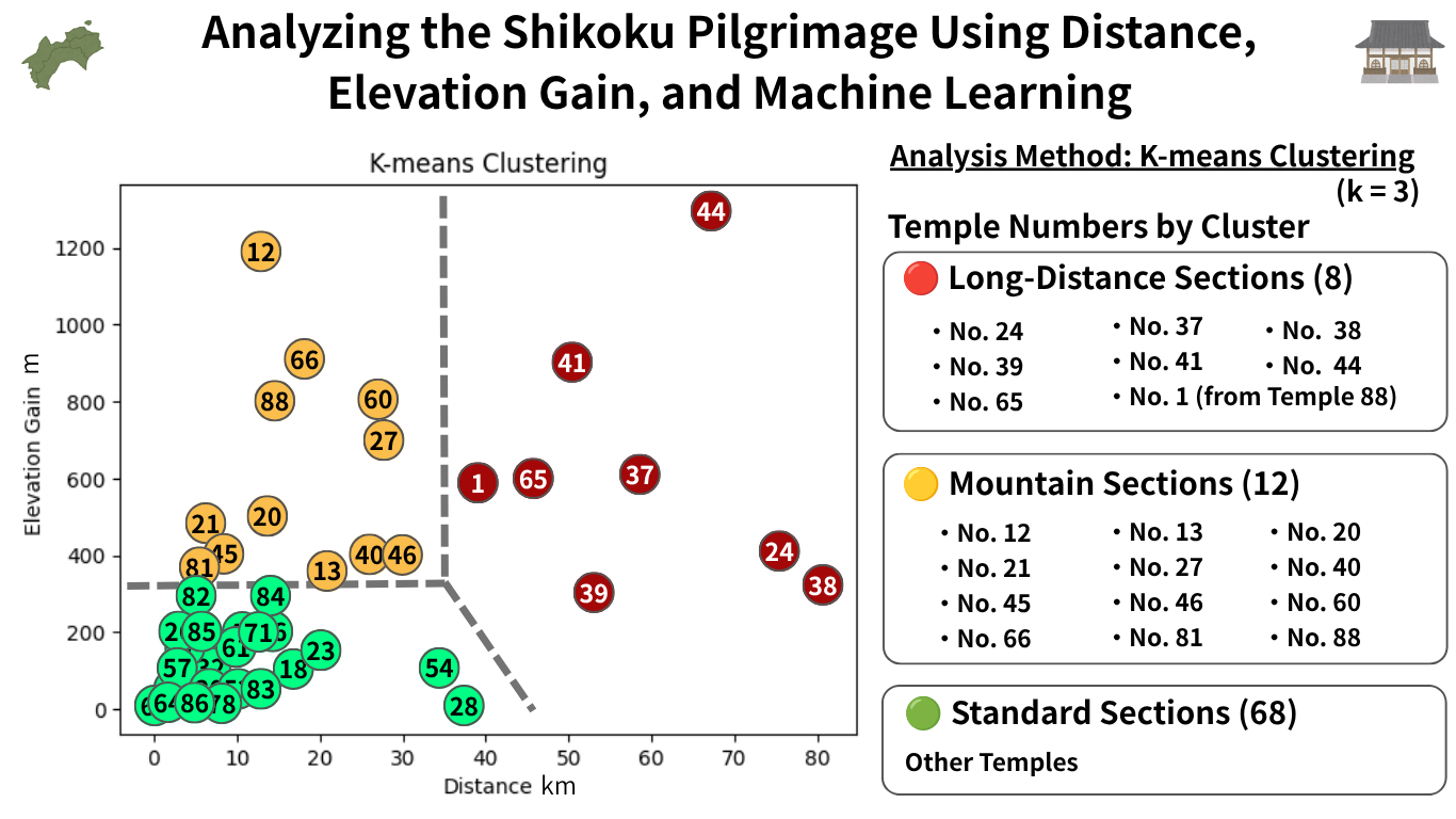
Data-Driven Analysis of the Shikoku 88 Temple Pilgrimage Using K-Means Clustering.
The Shikoku Pilgrimage Through Data
Walking Shikoku Pilgrimage Resupply Points List
Key Convenience Stores Near Convenience-Store-Free Sections
Below is a summary of major convenience stores located before and after the most important convenience-store-free stretches on the walking Shikoku Pilgrimage route.
These stores serve as critical resupply points for food, water, and other essentials. Temple proximity and location details are also included to help you plan your walking schedule and supply strategy more effectively.
Use this list alongside your route plan to ensure safe and well-prepared travel through sections where resupply options are limited.
Lawson Yoshinogawa Nishi-Oe Store
| Nearest Temple | No. 11 Fujii-dera |
| Google Maps | MAP |
FamilyMart Tokushima Kokufu-cho Store
| Nearest Temple | No. 16 Kanon-ji |
| Google Maps | MAP |
FamilyMart Tokushima Katsura Town Store
| Nearest Temple | No. 20 Kakurin-ji |
| Google Maps | MAP |
Lawson store in Naka Town
| Nearest Temple | No. 21 Tairyu-ji |
| Google Maps | MAP |
Wajiki Roadside Station
| Nearest Temple | No. 22 Byōdō-ji |
| Google Maps | MAP |
Lawson Anan Aratano Store
| Nearest Temple | No. 22 Byōdō-ji |
| Google Maps | MAP |
Lawson Hiwasa Teramae Store
| Nearest Temple | No. 23 Yakuō-ji |
| Google Maps | MAP |
7-Eleven Kaiyo Shishikui Store
| Nearest Temple | No. 23 Yakuō-ji |
| Google Maps | MAP |
Monmart Muroto
| Nearest Temple | No. 24 Hotsumisaki-ji |
| Google Maps | MAP |
Lawson Muroto City Hall Store
| Nearest Temple | No. 25 Shinshō-ji |
| Google Maps | MAP |
Convenience Okazaki
| Nearest Temple | No. 26 Kongōchō-ji |
| Google Maps | MAP |
Lawson Nahari Town Store
| Nearest Temple | No. 27 Kōnomine-ji |
| Google Maps | MAP |
FamilyMart Tosa Usa Store
| Nearest Temple | No. 36 Shōryū-ji |
| Google Maps | MAP |
7-Eleven Susaki Kirima-Minami Store
| Nearest Temple | No. 36 Shōryū-ji |
| Google Maps | MAP |
FamilyMart Nakatosa Kure Store
| Nearest Temple | No. 37 Iwamoto-ji |
| Google Maps | MAP |
Lawson Shimanto Town Chuo Inter Store
| Nearest Temple | No. 37 Iwamoto-ji |
| Google Maps | MAP |
Lawson Shimantocho Kanamono Store
| Nearest Temple | No. 37 Iwamoto-ji |
| Google Maps | MAP |
Lawson Kuroshio Saga Store
| Nearest Temple | No. 37 Iwamoto-ji |
| Google Maps | MAP |
Lawson Kuroshio Town Oga Bypass Store
| Nearest Temple | No. 37 Iwamoto-ji |
| Google Maps | MAP |
Lawson Shimanto Takeshima Store
| Nearest Temple | No. 38 Kongōfuku-ji |
| Google Maps | MAP |
Lawson Tosashimizu Shimonokae Store
| Nearest Temple | No. 38 Kongōfuku-ji |
| Google Maps | MAP |
Lawson Tosashimizu Asahimachi Store
| Nearest Temple | No. 38 Kongōfuku-ji |
| Google Maps | MAP |
Lawson Sukumo Hiratacho Store
| Nearest Temple | No. 39 Enkō-ji |
| Google Maps | MAP |
FamilyMart Uchiko Store
| Nearest Temple | No. 43 Meiseki-ji |
| Google Maps | MAP |
Lawson Kumakogen Kuma Store
| Nearest Temple | No. 44 Daihō-ji |
| Google Maps | MAP |
FamilyMart Kuma Irino Store
| Nearest Temple | No. 44 Daihō-ji |
| Google Maps | MAP |
FamilyMart Matsuyama Omura-cho Store
| Nearest Temple | No. 48 Sairin-ji |
| Google Maps | MAP |
Ministop Tanbara Imai Store
| Nearest Temple | No. 60 Yokomine-ji |
| Google Maps | MAP |
7-Eleven Komatsu Shinyashiki Store
| Nearest Temple | No. 61 Kōn-ji |
| Google Maps | MAP |
FamilyMart Shikokuchuo Ohgashiwa Store
| Nearest Temple | No. 65 Sankaku-ji |
| Google Maps | MAP |
FamilyMart Kanonji Awaicho Store
| Nearest Temple | No. 67 Daiko-ji |
| Google Maps | MAP |
FamilyMart Sakaide Fuchu Store
| Nearest Temple | No. 80 Kokubun-ji |
| Google Maps | MAP |
Ministop Danshi Store
| Nearest Temple | No. 82 Negoro-ji |
| Google Maps | MAP |
Lawson Sanuki Nagao Myo Store
| Nearest Temple | No. 87 Nagao-ji |
| Google Maps | MAP |
FamilyMart Awa Ichiba-machi Kita Store
| Nearest Temple | No. 10 Kirihata-ji |
| Google Maps | MAP |
Comments